| Portsmouth, NH Harbor see map and photos of trip |
|||||
| Date | August 12, 2000 | Time | 1015 to 1545 | Trip Length | 11 nm |
| Weather | Sunny, clear skies, 70F. Wind NE 15-20 knots. Seas 3-5 ft. at harbor mouth, <2 ft. in protected areas. | Tides | L 0415 H 1032 L1616 |
||
| Launch Site | Kittery Point Town Wharf behind Frisbee's Store, just off ME103 (limited free parking; more available at a school across the street) [ ONLINE CHART FROM MAPTECH ] [ DRIVING DIRECTIONS TO LAUNCH ] |
Landing Site(s) | ·Bridge at Cutts Island ·Odiorne St. Park, Frost Point |
||
| Route [ SEE MAP ] |
Paddle NE up Chauncey Creek; examine salt marsh NE of Gerrish; pass under bridge W of Cutts Island; paddle E through salt marsh to Brave Boat Harbor (note: both salt marshes are impassable at low tide; also, Brave Boat Harbor is shallow and has a narrow entrance, yielding large breakers in an easterly wind); return to Portsmouth Harbor, landing at the Cutts Island bridge to stretch; follow Gerrish Island shore S to pass Wood Island; paddle SW between Whaleback Reef and Wood Island, crossing the shipping channel and entering Little Harbor (use extreme caution: Portsmouth Harbor is extremely busy, and shipping channels should be crossed with great care); land for lunch at Frost Point, which is protected by a breakwater; briefly explored Witch Creek to the SW; paddled NW under two bridges (note: current under the southernmost bridge in this channel is very strong at maximum flood/ebb); remained along the southwestern shore of the Piscataqua until the green marker labelled "SBS" (use caution: the South Beacon Shoals are very shallow and create large waves in strong tidal currents), then crossed the channel to the NE to round Seavey Island (use extreme caution: Portsmouth Harbor is extremely busy and attracts large freighters, so use care when crossing channels); paddle E through the Back Channel, rounding Kittery Point to return to the ramp | ||||
| Trip Description [ SEE PHOTOS OR |
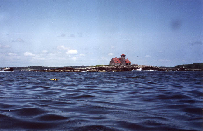
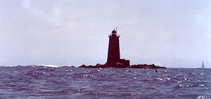
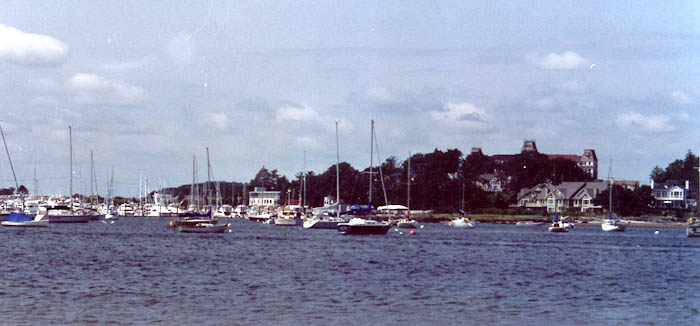
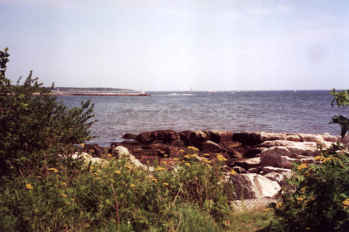
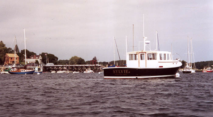
Portsmouth Harbor provides an interesting combination of accessible wilderness areas, picturesque oceanfront communities, and the hustle and bustle of New Hampshire's only deep-draft harbor. This trip reaches all three sides of Portsmouth Harbor in an easy day's paddle. The launch is located behind Frisbee's on ME103, and provides limited free parking (most spots are labelled 1 hr.; I got an unlimited spot). I put in and paddled right into the wind up Chauncey Creek, an out-of-the-way bay lined with trees and cute houses, plus the Chauncey Creek Lobster Pier. After passing a half-hearted breakwater near the Cutts Island bridge, I entered a salt marsh and followed the channel for a fair distance through the marsh grass. This marsh is surrounded by trees and a few large houses, but provides little in the way of visible wildlife or solitude; that was to come later. I retraced my steps back to the bridge, snapping a picture of a cormorant perched on a piling, and passed under the bridge against a minor current; however at full flood or ebb the current is quite strong. The road marks the edge of a Federal Wildlife Sanctuary, labelled in Tamsin Venn's Sea Kayaking the New England Coast as a Rachel Carson Preserve. Once inside, I found a secluded salt marsh with a (mostly) wide channel and no development on the shores. These channels empty at low tide, but for a decent time surrounding high tide they are navigable. Cranes flew overhead and landed onshore nearby, and mussels lined the shore. I shared the marsh with no one except a few picnickers in Brave Boat Harbor. Once in the harbor, the marsh extends, channels become wider, and one could spend hours simply exploring the area, if it wasn't for the tide. I passed through a bank of wooden pilings, which span the harbor and prevent powerboats from entering the wildlife sanctuary, and headed toward the harbor mouth. I soon realized that passing out of this harbor would be difficult, if not impossible, as the narrow and very shallow mouth generates huge breakers, and in the northeast wind of the day I let one six-footer pass under me before I turned around. For future reference: circumnavigation of Gerrish Island requires an ocean passage to the mouth of Brave Boat Harbor, then a carefully negotiated passage through the mouth. I proceeded to rush back through the sanctuary so as not to be caught by low tide, and passed under the bridge with a fairly strong current. I stopped onshore just after the bridge to stretch, and a crab sporting a five-inch diameter shell crept sideways by me, barely under water. I headed back down Chauncey Creek and turned south along the shore, passing to the east of Gooseberry Island and Fishing Island. I used the rocky coast in a photo of Whaleback Light and the old Coast Guard station on Wood Island. I passed through a series of pilings to the east of Wood Island and headed toward Little Harbor, passing to the north of Whaleback Reef. A kind boater stopped to check on me as I paddled across the harbor, as the strong northeast wind had brought up 4-foot seas at the Portsmouth Harbor entrance, but I assured him I was fine. The calm waters of protected Little Harbor were a relief, and I landed on the beach at Frost Point, part of Odiorne State Park. The many moorings in Little Harbor provided a perfect photo opportunity, and the rocks on shore provided a perfect lunch spot. After my respite, I briefly explored Witch Creek, then headed northeast under the bridge (which had a strong opposing ebb current as the tide was going out) and up the channel. This section of the harbor sees mostly recreational traffic, and at high tide would provide extensive opportunities for exploring tidal flats; one could also travel up Sagamore Creek. I passed under the bridge and had the view of a huge, working naval base in front of me; the sight is not necessarily as appealing as it is amazing. I remained on the opposite side of the channel, out of shipping lanes and in side eddies to avoid the current, then crossed the channel just before the green marker "SBS," which marks the South Beacon Shoals. These shoals are shallow and generate large waves in the strong tidal currents, so avoid them by crossing the channel. Just remember to stay sufficiently away from the naval base, as you will be arrested for boating too close, and be extremely careful of harbor traffic in the channel. I immediately entered the Back Channel behind Seavey Island, and was greeted by an adorable collection of houses along the shore, boats moored throughout, and lobster pot floats speckling the surface. This channel borders the village of Kittery on the north and the naval base on the south, but the congestion visible on the southern portion of Seavey Island is not reproduced on this northern shore, so I enjoyed this relaxing end to my trip. I finished by paddling past Kittery Point and back to the wharf, making sure to take a good photo of a Kittery Point boat. I returned to the ramp at low tide, but only had to carry my boat about 15 feet to reach the concrete. This trip was a wonderful juxtaposition in many respects: wildlife sanctuary and naval base, calm salt marsh to 4-foot waves in the harbor. Please be careful when paddling here, however, because harbor traffic is dangerous, and a kayaker drowned here earlier this year (presumably due to hazardous tidal currents, though I don't know for sure). Enjoy! | ||||


You are visitor number
© 2000 Daniel E. Smith. Last updated 8-22-00