| Scarborough Marsh, ME to South Portland, ME see map and photos of trip |
|||||
| Date | August 29, 2000 | Time | 1200 to 1745 | Trip Length | 17 nm |
| Weather | Sunny, clear skies, 75F. Wind S 10-15 knots in marsh, 5-10 knots on ocean. Minimal waves on marsh; seas 2-3 ft. at Scarborough Harbor entrance, 1-2 ft. on open ocean. | Tides | H 1139 L 1739 H 2355 |
||
| Launch Site | Scarborough Marsh Nature Center ME9 in Scarborough, just S of US1 [ ONLINE CHART FROM MAPTECH ] [ DRIVING DIRECTIONS TO LAUNCH AND TAKEOUT ] |
Landing Site(s) | ·Richmond Island (lunch) ·Simonton Cove Beach, near Spring Pt., South Portland (takeout) |
||
| Route [ SEE MAP ] |
Launch at the Scarborough Marsh Nature Center; paddle out of the marsh under the railroad bridge and past Pine Point (generally SE); pass through Scarborough Harbor entrance (note: tidal currents in the marsh and at the harbor entrance can be quite strong, so plan for them and be prepared); pass S of Prouts Neck and head E toward Richmond Island; land at the island end of the breakwater for lunch, carrying across the sandy beach; paddle around Cape Elizabeth and head N toward Portland Head (caution: Trundy Reef is shallow and must be avoided); round Portland Head and paddle NE to the takeout at the beach in Simonton Cove; car shuttle back to vehicle parked at the marsh. | ||||
| Trip Description [ SEE PHOTOS OR |
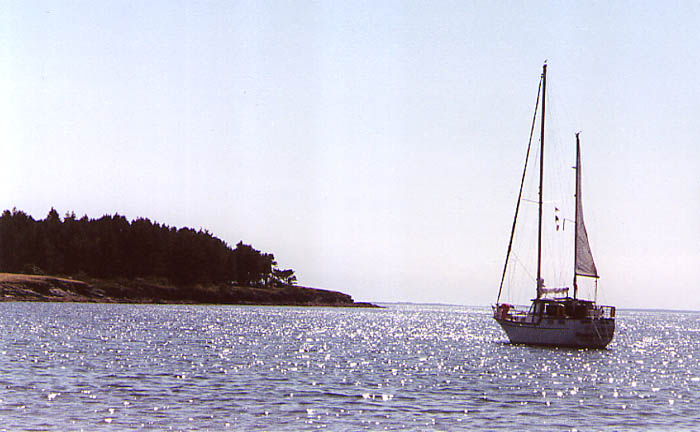
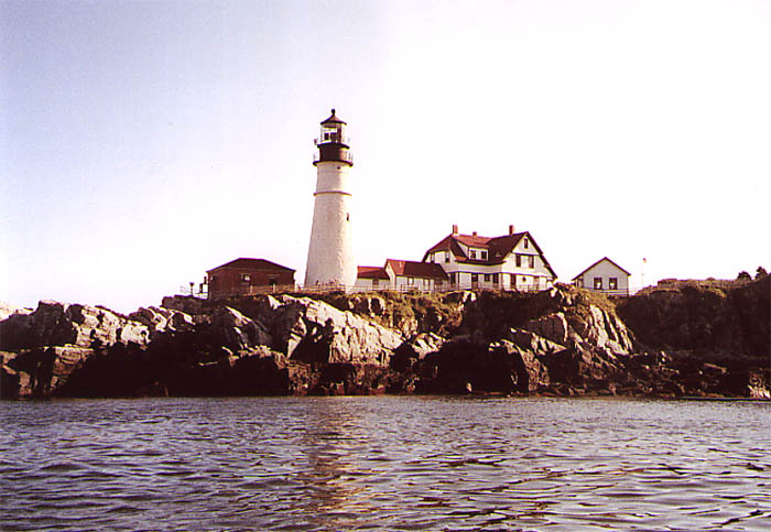
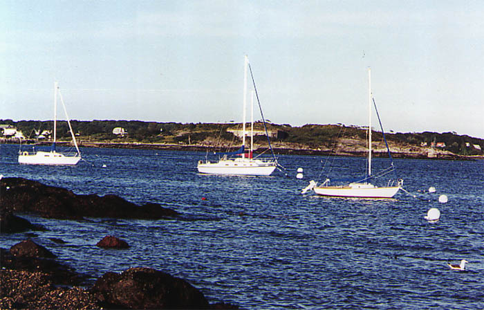
I'd been to Portland Head Light in the summer of 1995, and my life was very different then. I was 17, I had just graduated from high school, and though I canoed a bit with my brother I had never set foot in a kayak. I decided it was time to go back and be inspired again. I found that there is nothing more inspirational than sitting 100 yards off Portland Head watching the waves on the rocks and the landlubbers straining to lean over the fences in a vain attempt to see the lighthouse the way I did. But the start of this trip is a far cry from such prominent grandeur. The grandeur of Scarborough Marsh lies in its immense biological productivity as a salt marsh and the fact that the State of Maine had the foresight to protect it. My brother Greg and I put in at the Scarborough Marsh Nature Center operated by the Audobon Society. They have a nice operation with canoe rentals, naturalists, and a gift shop. One of the amusements of such a rental spot is watching parents each get into a canoe with a small child in the front seat and paddle off with the tidal current--only to realize 20 minutes later that they can't paddle back. But hey, we have to start somewhere. Scarborough Marsh is a joy and a nuisance to paddle. By virtue of state-owned land, the shores are relatively free from development (except for a prominent pipeline which crosses the marsh on a bridge), and the marsh is a haven for birds such as cranes, sandpipers, and cormorants. However, like many salt marshes, the channel meanders such that it seems to take forever to paddle very far (wait until you've paddled 20 minutes to that bridge, whereupon you look back and see the nature center barely 1/4 mile away), and the wind and current can be bothersome at times. It is best to plan any trip here around the tides, which peak at the nature center about an hour after Portland. We put in just before high tide, and had to paddle against the current for the first 30 minutes or so. After passing under the railroad bridge, which can be dangerous in conditions of strong tidal current, we reached Pine Point, a small town on the south shore of Scarborough Harbor. The tide turned in the marsh soon after we started, so the current was flowing strongly out of the harbor when we passed through the entrance. With a southerly wind, we had to fight some large waves. Keep to the eastern side of the channel, which is shallower and has slower current. After exiting the harbor, we were greeted by the beautiful rocky head of Prouts Neck, topped with large, graying wooden houses. Continuing northeast, we set a course for Richmond Island straight across the bay. While paddling this stretch, we heard a sound which both made us stop, look confusedly at each other, and scratch our heads while scrutinizing the water for some sign of what might have made the noise. The bird called again. "A loon?" "That's the only thing that makes a noise like that." Sure enough, there were two puffy, gray loon yearlings floating off to starboard. It was then that Greg recalled that loons spend their first year after fledging on the ocean. In all, we saw eight loons on the trip, including a male who was quite interested in keeping another youngster away from his partner, and made it readily apparent to the invading male, who went skittering rapidly away. We landed for lunch on the beach abutting the breakwater on the north shore of Richmond Island, which is owned by the Sprague Corporation but is open for public use to all who can reach it by boat. The island is virtually free from development and provided an excellent place for lunch and a brief beachcombing expedition, which yielded numerous sand dollars, crab shells, and some very large clam shells. If one desired, one could spend an hour or two wandering the island, which looked to have some picturesque rocky shoreline on the southern end. We instead carried across the beach and paddled across Seal Cove to Cape Elizabeth. The tourists were out in droves at Two Lights State Park, crowding on the headland cliffs of the Cape. The coast here was a real treat, rife with small rocky points and (not surprisingly) two lighthouses. The Cape Elizabeth Light is operational, but its twin was retired in the 1920's and now serves only as a photo opportunity. Immediately after rounding Cape Elizabeth, the Portland Head Light comes into view and dominates the surrounding coast. At the north end of Cape Elizabeth, Trundy Reef extends northeast from Trundy Point, and though nothing out of the ordinary is charted, we almost ran aground on what seemed to be a wall submerged under less than two feet of water. We realized slightly too late that the waves broke over the wall in a rather dangerous fashion and we wished that we had instead rounded the reef. I avoided a capsize with a reflexive bracing stroke, and no ill effects were rendered. Placated by the approaching beacon, I again set my sights on Portland Head. One cannot describe in words the appearance of Portland Head Light from the water. Illuminated by the late afternoon sun and sitting high on the rocks, the red-roofed structure was amazing to behold. I gaped at the cliffs and associated breakers, and gazed reminiscently at the rocks I had climbed on five years before. Never did I think I would have come so far, and still have so far to go. Putting the head behind us, Greg and I paddled for the Spring Point Light, where our parents were supposed to have dropped a car. After beaching at the Simonton Cove beach, we searched in vain for a vehicle and relegated ourselves to waiting for Mom and Dad. I sat on the water's edge, replenishing my carbohydrates with dried apricots, watching the tide come in, gazing at the fort across the harbor and Portland Head in the distance, and prying the tide pools for hermit crabs, who had capitalized on the large snail population by recycling old shells. It turns out that our parents had decided to do some lighthouse-hopping in the hopes of seeing us, and ended up being an hour late at each stop. We finally carried the boats up the stairs to our car and drove back to the marsh, ending an amazing day of paddling. Portland offers many options for sea kayaking which I plan to pursue, most importantly the islands of Casco Bay. Another day... | ||||

You are visitor number
© 2000 Daniel E. Smith. Last updated 9-8-00