|
Located within the Boston city limits, the 34 islands of the Boston Harbor Islands National Park Area provide a strange and refreshing juxtaposition of urban center and uninhabited shoreline. Less than an hour's drive from downtown, paddlers can experience the joy of paddling to a deserted island steeped in history and offering glorious views of the Boston skyline and the Atlantic Ocean. To see a map of this trip, including the route, launch sites, caution areas, and public lands, click here. What You'll See The outer islands of Boston Harbor, those north of Hull and east of Long Island, are a wonderful destination for kayakers. Not only are several of the islands open to day visitors, but two offer camping.
The geology of the islands varies from sandy dunes (Gallops and Lovells Islands) to high glacial drumlin (Great Brewster Island) to rocky outcrop (Middle and Outer Brewster and others). Several islands have visible historic sites or ruins.
The route described below passes two lighthouses. The Graves Light lies on a small, rocky outcrop far from civilization, and is visited only by fishermen and curious paddlers.
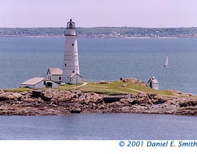
In contrast, Boston Light is surrounded by a manicured lawn with flower beds, a well-kept keeper's house, and a large dock for the ferry to bring visitors from downtown Boston.
Launch Sites To reach the outer islands, launch from Windmill Point at the tip of the Hull peninsula. Here there is a sand-to-gravel beach adjacent to the MBTA ferry terminal, and parking is free. If paddlers wish to avoid the strong currents of Hull Gut, they should put in on the north side of the point.
Trip Route Follow this description closely on the route map. Starting from Windmill Point in Hull, make the one-mile crossing to Fort Warren on Georges Island. After a tour, head east past Lovells Island through the Black Rock Channel to reach Great Brewster Island, a scenic lunch spot. |
|
If the weather permits, paddle northeast to the Graves Light, and return south to Little Brewster Island, the home of Boston Light (shown above). Finish the trip by returning to Windmill Point.
Public Lands While almost all the islands along the trip route are part of the National Park Area, it is easiest to land on Georges, Lovells, Peddocks, and Great Brewster. More information about camping on Peddocks or Lovells, including reservation information, can be found here. Little Brewster is managed by the Coast Guard, and its operating hours can be found here. As of Fall 2004, Gallops remained closed to the public because of asbestos-containing debris on the island. Caution Areas Hull Gut experiences especially strong currents, reaching almost three knots at maximum. The resulting large standing waves, when combined with heavy boat traffic and boat wakes, make this a dangerous place. Avoid paddling through Hull Gut except within one hour of slack current.
Nantasket Roads, the channel between Hull and Georges Island, is a major shipping lane into Boston Harbor. This one-mile crossing gets especially dicey on summer weekends with recreational boat traffic, or when the wind blows from the east or southwest.
The leg to and from the Graves is completely exposed to the open ocean. Not only is there a 1.5-mile crossing, but it may be impossible to land at the Graves. Do not attempt this leg if the weather looks at all intimidating.
To make matters worse, a group of partially submerged rocks called the Roaring Bulls lies along the route to the Graves and creates rough seas with very little swell. Be sure to avoid them.
|