 |
Perhaps the most important tenet of kayaking safety is "do not kayak above your ability." For most kayakers, being in over your head usually results from winds that are too strong or seas that are too big.
The keys to selecting a day when it is safe to kayak are to have an up-to-date weather forecast and an ability to translate that forecast into an accurate portrait of the sea state.
Marine Weather Forecasts
So how do you know what to expect out on the ocean when your local TV weatherman forecasts a clear day with a high temperature of 64 degrees and 5- to 10-mile per hour winds? The answer: don't ever listen to your TV weatherman when it comes to wind speed.
Instead, kayakers need a marine weather forecast designed to forecast the sea state. A marine forecast will give you a prediction of the wind speed, wave height, and potential for fog, providing information critical to your decision of where and whether to kayak. As an example, here is the current marine forecast for Block Island Sound off Rhode Island. Once you have obtained the current forecast, try to create a picture of the described sea state in your head. For example, when the forecast says "seas 2 feet," one-third of the waves will be 2 feet, or chin-high. And for a bit more perspective, a kayaker must look up to see the top of a 4-foot wave.
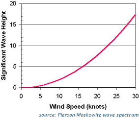
Paddlers can also predict the height of waves simply from the wind speed. The graph below shows the expected height of the highest one-third of waves (significant wave height) resulting from a wind blowing across several hundred miles of open water for one day or more.
|
|
These predictions do not take into account swells generated by faraway storms, which can be much larger than the local winds of the day might generate. Therefore, always check the marine forecast, which will warn of large swells.
The Beaufort Scale
Another way to create a picture of the sea state in a given wind speed is to use the Beaufort Scale.
During the 19th century, anemometers did not exist, and mariners had no reliable way to estimate wind speed. To provide a standardized method of describing and measuring wind speeds, the British Navy's Admiral Beaufort created a scale where winds were categorized by a "force number." This scale now bears his name.
The Beaufort Scale, shown on the following page, includes 13 levels of wind speed, from Force 0 ("calm") to Force 12 ("hurricane," now known to be wind speeds over 63 knots). Each force has an associated sea-state description. For example, in a "gentle breeze," now known to be winds of 7-10 knots, paddlers can expect "large wavelets, crests starting to break, some whitecaps."
Mariners used the scale by looking at the sea state and identifying the force number that fit. That way, they could communicate wind speeds to others without scientific instruments. Later, when the anemometer was invented, scientists applied numerical wind speeds to the force numbers that had been used for decades.
Kayakers can use the Beaufort Scale to predict the sea state they will experience in a given wind, assuming that the wind has been blowing for a long time and the area in which you paddle is not protected from waves (say, behind a barrier beach or island).
Novice paddlers should try to develop a realistic assessment of various conditions to allow better judgments about whether or not to paddle. After you paddle, check the local buoy observations to determine the actual wind speed and wave height during your trip, and compare this data with your perceptions about the conditions. Make quick notes for future reference, such as "12 knots reported: waves over my head!" |