 |
The sight is amazing to those unsuspecting (and often, too, the suspecting) visitors to the coast: return six hours later to the same spot and the shoreline will look entirely different. Rocks, sand, and seaweed either appear or disappear as the water level rises and falls in a phenomenon called the tide. The tides here in New England are some of the largest in the country, and this article will help you understand their causes and predict their behavior.
Tides are caused by the pull of the moon's gravity on the Earth's oceans, causing a tidal "bulge" to form under the moon's position. Another bulge forms exactly oppposite this one, on the other side of the Earth. As the Earth rotates under the moon, these tidal bulges appear to move around the Earth.
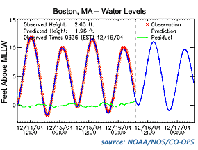
What we observe in one location on the coast is a regular rise and fall of the water level, from a maximum called high tide to a minimum called low tide. An actual graph of the changing water level is shown below.

 Timing of the Tides For kayakers, understanding the timing of the tides is very important for safety and planning. Because the Earth rotates once every 24 hours, approximately two high-tide bulges pass during each 24-hour period.
However, the moon also revolves around the Earth every 28 days. This movement means that the tidal bulge reaches the same position on the Earth 50 minutes later each day. Therefore, if a high tide occurred at 10:00am one day, it would occur around 10:50am the next. Consecutive high tides, then, occur about 12 hours 25 minutes apart.
|

|
What about low tides? Low-tide troughs alternate with high-tide bulges, so low tide occurs about 6 hours 15 minutes before and after high tide.
 Tide Range In New England, we experience a semi-diurnal tide: two high tides and two low tides each day. Often, the difference in water level between high and low tide, called the tide range, is not the same for the two tide cycles. Usually, the higher high tide occurs as the moon passes overhead, while the lower high tide occurs opposite the moon.
The tide range varies significantly based on your location. For example, the average tide range from Provincetown to Mount Desert Island is around 8-10 feet. However, south of Cape Cod, the range rapidly diminishes to 2-4 feet. This difference is due to the shape of the Gulf of Maine and its effect on the moving tidal bulge.
Tide range also varies depending on the lunar cycle. During the full moon, the moon and sun are aligned on opposite sides of the Earth, and their combined force increases the tide range. A similar effect occurs during a new moon, when the sun and moon are aligned on the same side of the Earth. These larger-than-normal tides are called spring tides.
The alternative, when the sun and moon are out of alignment during the quarter moons, is a neap tide. The neap tide range is smaller than average. For example, at Little Deer Isle on Eggemoggin Reach in Maine, the mean tide range is 10.0 feet, while the spring range reaches over 13 feet and the neap range can be less than 8 feet.
 Tide Predictions Because the water level determines the shape of the shoreline and the depth of underwater hazards, kayakers should always check the tide predictions before setting out for the day. Tide predictions are provided by NOAA's National Ocean Service. A sample is provided on the next page.
|
